First Commercial, large-scale mapping created independently of Ordnance Survey
The GeoInformation Group today announces a ground breaking and innovative new mapping programme. UKMap is the UK's first commercially funded, large-scale topographic mapping and address database created completely independently of the Ordnance Survey.
Started more than two years ago, the GeoInformation Group can reveal for the first time the full scale of the UKMap Programme. Employing more than 100 people across three continents, UKMap forms part of an ambitious five-year programme to map over 500 towns and cities covering all urban areas with a population greater than 10,000 — some 24,000 square kilometres throughout the UK.
London is the first complete UKMap city covering over 1,700 sqkm and is available on 1 September 2009. Areas to be published in 2010 include the West Midlands conurbation, Merseyside, Manchester and parts of Yorkshire.
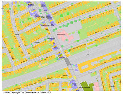
UKMap is a highly detailed, feature rich mapping database, which comprises integrated map layers and attribute tables. Captured for use at 1:1,000 scale, UKMap includes buildings with 3D information, road detail including pavements, lane markings, pedestrian crossings and speed humps, a full address gazetteer, inferred property boundaries, land use coding and a wide range of points of interest. It also includes aerial photography and terrain layers.
"The technology changes of the last few years have made the creation of UKMap not only technically feasible but commercially viable. There is a growing demand for choice when it comes to mapping. We believe the time is right for the UK mapping industry to provide GIS users with that choice." says Seppe Cassettari, CEO of The GeoInformation Group.
"We have invested a considerable amount of time and effort in the development of UKMap and have now secured long-term funding along with commitments from a number of commercial partners which ensure the programme can achieve its ambitious targets."
From the outset, an active UKMap forum, comprising key industry representatives, have advised on the development of UKMap. Forum member Alisdair Maclean, GIS Manager of London Borough of Brent, comments, "UKMap represents a revolution in mapping and brings the provision of large scale mapping in the UK into the 21st Century. For the first time, users of large scale maps will not only have an accurate and feature rich layered solution, but have it in a format of their choice"
Alun Jones, Managing Director of The GeoInformation Group adds "UKMap also offers choice with innovative licensing and flexibility when it comes to IPR, publishing and on-line distribution. We strongly believe that this will revolutionise the way many people think about using large scale geospatial information."
UKMap offers a significant amount of new and essential location information which is capable of supporting professionals within a vast range of applications including; asset management, flood modelling, highway management, network planning, crime and incident analysis and urban design.
To find out more about UKMap or request a sample, go to www.theukmap.co.uk.