Google mapping added to Navman Wireless vehicle tracking system Real time traffic information and street view maps have been introduced to Navman Wireless's vehicle tracking system, giving businesses unrivalled control over their fleets and cementing the company's position at the fore of technological development.
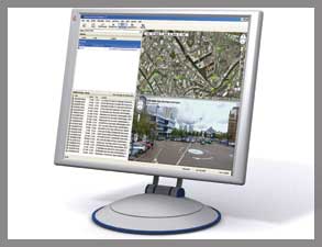
The dynamic new features, provided by Google Maps, will enable companies using Navman Wireless's award-winning OnlineAVL2 software to more accurately determine off-site locations and better optimise journeys to and from customers and suppliers.
"In-depth traffic reporting, detailing traffic speeds, will ensure business and transport managers can improve their response times by routing their vehicles to avoid traffic congestion," said Steve Blackburn, European Vice President, Navman Wireless.
Steve continued: "To help pinpoint driver locations and destinations, users can also toggle, at the touch of a button, between traditional mapping and aerial photographic images or zoom in to see detailed, high resolution, panoramic street views.
"We have introduced the new geographic functionality in response to customer feedback and will be providing it to them free of charge."
Navman Wireless, the UK's largest provider of vehicle tracking*, remains at the fore of telematics and mobile data development and has committed to continuing its multi-million pound investment into research and development for 2010.